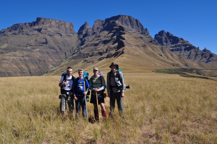
Four friends embarked on a journey into the mountains. Here is their story …
There was still much to do especially since we had left around an hour later than planned because Mike battled get away from work in time. But in due course, he picked up the trio of Jeff, myself and Paul. As the sun started to drop like a stone, Paul had to buy a map of the Injasuthi area and Mike had to buy snacks. The Parks-board Office in Petermaritzburg was practically closing and they did not have a copy of the one map we needed, but they kindly made a photocopy for us and we were now finally off to Injisuthi. However, we would have to make up some serious time if we were to make the 1800 gate time. As it became clear this would not happen, Paul called ahead and asked them very nicely if the could leave the gate open for us. Now the final piece of road into the camp is seriously poor, so it took a while for the heavily laden Corolla to bounce and dodge the potholes and detour around the 3 year debunked bridge in the valley.
We arrived in the dark and cold of the Middelberg night and geared up as best we could for the supposed 7km hike to Wonder Valley Cave. It was headlamps on and 1900 when we illegally set off up into the mountains. After scampering up the short O’Hannigans Pass, the moonlight really took over and we travelled quickly over flat ground. There were a few navigational issues which caused us to double back a number of times and eventually added about 3km to our journey. At 2230 we were happily greeted by our overnight stop. It was a fantastic cave with plenty space, sheltered from the elements and close to a water source. Once we had settled in, it was out with the cookers for tea and noodles. The night in the cave was comfortable, though we did wake up a little late because the sun rose on the other side of the ridge.
On Day 2 we had 21km to cover over relatively flat ground once we had hit the contour path. The view of Monks Cowl and the surrounding peaks was utterly spectacular and for the first time we realised how deep into the berg we were and began to appreciate our surroundings a lot more. Around 0930 we took a brake on a flat plain and chucked a frisbee around in a sought of tribute to the Prawn Bunny practice taking place at the same time over 250km away at UKZN. When the energy from the oats that morning ran out, we stopped for lunch at an awesome little shady pool next to the trail. This pool, needless to say, was extremely cold. Nevertheless, we were pretty stinky already so a bit of a wash was in order. So it was off with the kit and out came the environmentally friendly soap. To his credit, Mike was the only one brave enough to don the birthday suite and completely immerse himself in the mountain bath. This was followed by girly screams and much laughter.
It was a little hard to find, but we got to our destination of Keith’s Bush Camp about an hour after the sun had dropped behind the mountains. The setting of the campsite is very impressive as it is situated in a valley where the mountains of the escarpment border three sides and there is a river on the fourth. But because it’s the dry season, the river was exceptionally parched. This was a bit of a worry because in the mountains, water is life, and now all we had was a few sips in our bottles and the last water point was over 2km back down the path. Fortunately, Jeff found what was essentially a puddle no deeper than a can of Coke. It was from here that we replenished our water after filtering through Paul’s slightly snotty handkerchief and boiling it. It was humbling to spend so much time and effort to procure the most simplest of things, things that are ‘needs’ as opposed to ‘wants’. In the mountains you are reduced to the basics of human needs. Its rad.
At any rate, the position of the campsite also gave us an idea of the size of the challenge that lay ahead because it was at the foot of Grey’s Pass and the mountains that we planned to be on top of the next day. That nights 3 course mountain-meal included tea, noodles with bacon and some chocolate. It was bladdy delicious. Because there was a Pass and much ground to cover on the escarpment the next day, it was early to bed and early to rise. However, we were all sleeping in the tent that night and it was quite a tight fit to say the least. If you turned over, snored or sneezed it would wake pretty much everyone up. As a result of this, we were all up at 0300 and a decision was made that instead of pretending to sleep, we should rather start the day a little earlier. So there we were at 0400 making breakfast under the stars.
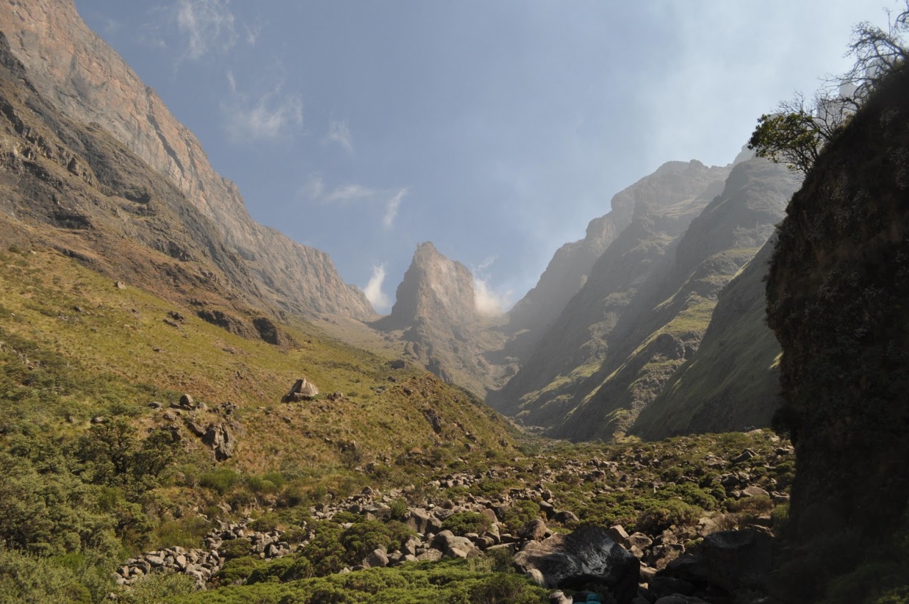
We departed at around 0530 to head up Grey’s Pass, which was over 1000 vertical metres and 3km from the camp. The higher we climbed the more incredible the views were and the more treacherous the path became. Our spacious campsite was a mere speck on the mountainside. There were a couple scrambles as we reached the top of the Pass, and by ‘scrambles’ I mean rock climbing where if you make a bad mistake, you will, err, loose altitude rather quickly. Nevertheless, we all got up safely and took a well earned rest at the end. The escarpment is a very arid place indeed. Nothing grows higher than your shin and everything is kinda the same colour. Following our rest, we ambled down to the river to fill up, breaking the surface ice to do so. But the Pass had taken much longer than expected to conquer and a lot out of us physically, so our planned overnight stop at another cave would have to change. The closest summit to us and the third highest peak in South Africa, Champagne Castle, was an easy choice to make!

Map check about halfway up Greys Pass
Hiking on the escarpment is not for the weak. The path faded away and the ground became very uneven, thus making it difficult to get into any rhythm or even take a full stride. The wind also picked up and really hammered us on the way to the summit. Reaching the Champagne Castle peak lifted the spirits, and there were many photo’s taken. There was even a little rubber duck called Thrasher in some of them. Feeling a sense of achievement, we ambled down the windward side of the peak to scout out a place to set up camp.

Top of a blustery Champagne Castle
The Pass we would have to descend down the following day was called Ships Prow Pass, so it made sense to get into that area to camp. On the way there, we saw our first bit of snow on the shady side of a ridge. Others chowed down while I made a rad but modest snowman with a mowhawk. It was about 1400 when we found a flat grassy outcrop around 50 metres down the Pass itself. It had everything we really needed: snow for water, shelter from the wind and rocks for seats. And at over 3000 metres, it was the highest bedroom any of us had slept in. We sat down on the spongy grass and were asleep within 10 minutes. We had definitely earned that afternoon nap.
Later, it was time to collect snow and melt it so we could cook our most tremendous supper yet: bacon and cheese with noodles. The mountains make food taste simply amazing. As we patted our full tummies, we were all quietly remembering our horrid night in the tent that felt like a week ago. It was a slight relief when it was decided that we should sleep outside. After supper we set up some rocks to play cards, then it was definitely bed time as it was simply to chilly to do anything else.
That night we were supremely grateful for the quality gear we had, it did the job and kept us warm as toast. The wind picked up again during the night, making everything outside the solace of one’s sleeping-bag seem chaotic. In the morning we were greeted by the most fantastic sunrise our eyes had ever seen. A red belt of light formed on the horizon as we overlooked the misty valleys far below us. After our final bowl of oats, we melted as much snow as we could for the trip down Ships Prow Pass and said goodbye to the ledge that had treated us so well.
This is where things began to take a turn for the worse for our merry crew. The path down the beginning of the Pass was easy enough to follow, but it slowly disappeared and we eventually found ourselves having to bundu-bash to get to the river. According to the map, the ‘path’ criss-crossed the dry river a number of times before finally hooking up with a proper contour path that would take us all the way back to Injasuthi. But walking down this wide river consisted of either boulder hopping or hacking through vegetation. So we hopped and hacked our way down which took hours and was very energy sapping indeed. In sum, it took us 5 hours to reach the contour path which was a mere 3kms away from where we started the day. It was at this point that we could turn around and see what we had achieved. Looking up at Ships Prow from the valley itself was quite spectacular.

The Mighty Ships Prow Pass
With spirits lifted and the feel of a warm shower so near, we set off toward the contour path which is supposed to be like the N2 of paths, but instead we were welcomed by the equivalent of a dirt road under construction. It lead us through forests, thorn bushes and steep sandy banks which sucked up a lot of time. At any rate, it got better and we ploughed forth, gaining back some time in the process. We took a break on top of a ridge where Paul described the situation to us. In a nutshell, the path contoured around into the next valley and back again, basically doubling back on itself. So we could walk the route, adding 2 or 3kms to our route, or we could forge our own path over the spine of the ridge and meet up with the path at the bottom and save all that unnecessary trudging. Mike, Jeff and I all agreed before you could say ‘boskak’. And off we happily went.
However, the mountainside got steadily steeper and we reached a point of no return where it was too far to go back, but looking too steep to carry on. Paul used all his mountaineering skills to scamper down, then told us to shimmy around the side of this hill and make our way down on a less steep slope. On our way around, the gully separating the hillsides looked like it could lead us right down to where Paul was waiting for us, so I suggested we scramble down and no-one disagreed. Well, it turned out to be a bad move because we got around 70 metres down and found a waterfall. Great.
All 3 of us really struggled to clamber back up the gully and we then kinda realised how doff we had been. It was getting dark, Paul didn’t know where we were, we didn’t know where he was and none of us were on a path. After an age we crawled out the gully and shimmied around the mountainside on a 70degree slope, clutching grass as we went along. The 3 stragglers preformed admirably despite the one incident where I fell. I slipped and grabbed a tree branch which broke, causing me to slide down the hillside on my pack. There was a rock face coming up ahead but I said to myself that I would stop soon enough. I said that many times before I stopped. We had a short breather at the bottom then continued homeward bound along the real path.
There was some healthy reminiscing on the final stretch as we took out our headlamps for the last time. Over 50kms had been hiked, only 18 hours slept, 2 Passes completed and a 3370metre summit reached. It had been a very long 3 days, but in the end the now Awesome Foursome trundled into Injasuthi Camp sporting broad smiles at 1900. Mike gave us our singular celebratory Chockit (incidentally, the best biscuits ever) and we posed for one final photo.

The Best Biscuit in the World
Then the next chapter of the journey (that would last until 5am the next morning) opened up. We reached the gate of the Injasuthi Camp, which is a full 7 or so kilometres from the Main Office, only to find it closed. Jeff, in feat fuelled by a massive desire to be home, threw a big rock at the staunch padlock only to realise it was largely a futile exercise. So we turned around and weaved our way back to find the Rangers house. He used the radio to send a man with the key and we were off again. Outside the gate our phones began to beep profusely as our loved ones showed concern for where we were. Later, travelling down atrocious road, life gave Mike the driver a choice between a rock in a pothole and just a normal pothole. Unfortunately, the car did not clear the rock and it went thumping the length of the poor car’s underside. ‘Ooooooh’ we all said, but we sped on.
<It was at a Shell in the one-horse town of Winterton where we pulled in to fill up with petrol, only to see most of it come straight back out again onto the forecourt. There was a hole in the fuel tank. Following a few face-palms and cusses, the needle eventually levelled out at a quarter of a tank. Aside from getting home, food was also very high up on our needs list at that moment. We decided that there was enough fuel to get us to Steers at the Ultra City by Escourt. And it was, thankfully enough, and we stuffed our faces with oily goodness. Mike made the faithful Dad-please-help-me late night phone call and we waited. Luckily, we were kept entertained by the truck-stop which had some real characters prancing around. After all, as a trucker, there ain’t much to do except change gear, change gear, kill a prostitute, change gear etc.
Mike’s dad and Ryan arrived at around 2am with a Land Cruiser and a flatbed-trailer and explained to us that we had to sit in the back of the canopy-less truck for the rainy 2 hour journey back. By this time we were so over all the challenges that we all actually managed to sleep in the back of that wet ‘n windy Toyota. The foursome and their rescue party pulled into Durban at about 0430 tired and broken, but still stoked about the run-out-of-adjectives weekend they had just endured.
The Motley Crew
READ MORE: Tales from the Trails: 175km down the mighty Orange River